Our Heritage
Founding
The area known as Enfield was first settled in 1804 by John Giltner and Judah Baker. The land was originally part of the southern portion of Military Township Lot No. 22 in Ulysses. The Town was first registered in November, 1820 and officially incorporated by the State of New York on March 16, 1821.
Agriculture and Businesses
Historically, agriculture was the primary way of life for most residents. By 1865, 80% of the Town’s land was dedicated to farming. Industrial growth centered around local waterways, and by 1866, five sawmills were operating on Five Mile Creek.
Following the Civil War, the federal government encouraged the establishment of farmers’ organizations. In response, local residents organized and built the the Enfield Valley Grange No. 295 in 1925. As of 1995, it remained the only Grange Hall in Tompkins County still officially functioning.
Over the years, a diverse array of businesses have thrived in Enfield, including: general stores, shoemakers, coopers, blacksmiths, seamstresses, broom makers, saw and gristmills, auto sales and repairs, taverns, motels, bed and breakfasts, tree farms, local golf course, computer repair/services, self-employed construction businesses and plumbing/heating businesses, a fuel company, day care providers and an adult entertainment establishment.
Enfield Falls and Robert H. Treman State Park
Enfield Falls is located in the southeastern part of Enfield. The surrounding park is named in honor of Robert H. Treman, who gifted the land to New York State in 1920. A Grist Mill, constructed in 1838-39 operated there until 1916. Today, it remains a landmark where tours are offered during park season.
Governance
Enfield’s government follows the standard model for small New York State towns. The Town Board consists of an elected Town Supervisor (two-year term) and four elected Board members (four-year terms). Other elected officials include:
- Town Clerk / Tax Collector: Two-year term
- Highway Superintendent: Two-year term
- Town Justice: Four-year term
Administrative operations are based out of the Enfield Town Hall, which was constructed in 1966 at Enfield Center.
Geography and Demographics
The Town of Enfield is located in the rural, west central portion of Tompkins County. Enfield Center is approximately ten miles west of the City of Ithaca. The Town is bordered on the east by the Town of Ithaca, on the north by the Town of Ulysses, on the west by the Town of Hector in Schuyler County, and on the south by the Town of Newfield. Enfield encompasses 37.4 square miles.
As of the 2020 Census, Enfield’s population is approximately 3,401. The town’s geographic area is served by four public school districts: the Ithaca City, the Newfield Central, Odessa-Montour Central, and Trumansburg Central.
Town Historian
The current Town Historian is Sue Thompson, who may be reached in the following ways:
- Email historian@townofenfieldny.gov
- Call 607-272-6412
- 182 Enfield Main Road, Ithaca, NY
The Town Historian position is a volunteer position filled via Town Board appointment on an annual basis.
The Town Historian works with the Enfield Town Clerk in collecting and preserving the historical records of the town. They also educate the public about the history of Enfield through written articles and public programs, act as a resource on local history for local government officials, genealogists, and the public, and act as an advisor on issues of preservation of historic sites and buildings, and interpret the past history of the Town of Enfield.
The current job duties and responsibilities of a Town Historian have been adapted from the original position description in December, 2009 and includes the following:
- Submitting a yearly report to the Enfield Town Board, Tompkins County Historian, and New York State Historian.
- Answers inquires regarding Enfield and its Residents (genealogy) primarily from e-mails.
- Attends the following meetings: Enfield Town Board Meetings (periodically), Association Public Historians of New York State – District #10 (twice a year), Tompkins County Municipal Historians (TCMH) (monthly, held at the History Center in Ithaca NY).
- Participates in all TCMH projects.
- Participates in the Enfield Harvest Festival, Enfield Community Council events, and Display of Enfield History (Yearly).
- Submits history articles to the Town of Enfield Community Currents Newsletter and Town Government Newsletter.
- Updates the Town Historian web page.
- Acts as the Enfield Cemetery Committee Chair.
More Links
- Names on the Land – Tompkins County showcases the ongoing work of the Names on the Land research team which is meant to inform readers about how how people of the past settled the land, what areas they’ve explored, and what businesses or public sites they have built. Visit their blog (External Site).
- Read the Tour of Enfield Brochure (PDF, 666 KB).
- General Information about the Robert H. Treman State Park, including directions, geography, and hours open for hiking, camping, and swimming can be found on the NY State Website for the Robert H. Treman State Park (External Site).
- To find a specific document, you can check our public Laserfische repository. To read more of Enfield’s use of Laserfische, check our Documents page.
- Check our Throw Back Thursday series, which is where the Town Historian publishes weekly history articles.
- Read this document written by the Municipal Historians of Tompkins County and edited by edited by Carol Kammen on names of roads and landmarks in Enfield: Place Names of Tompkins County – Town of Enfield (PDF, 718 KB)
Enfield History Book
In the links below, you may locate PDF copies of the chapters for the book, The Town of Enfield, New York – Christian Hill to Enfield Falls. The book was edited by members of the Enfield Historical Society and Town Historian Sue Thompson in 2002.
Enfield History – Cover
Enfield History – Introduction, Table of contents, Time Line
Enfield History – Geology
Enfield History – Prehistory
Enfield History – Early Settlements and Crossroad Communities
Enfield History – Enfield Falls
Enfield History – Buildings
Enfield History – Transportation
Enfield History – Roads
Enfield History – Businesses and Doctors
Enfield History – Government Officials
Enfield History – Government – Community Council – Enfield Volunteer Fire Company
Enfield History – Religion
Enfield History – Education
Enfield History – Social Organizations
Enfield History – Military
Enfield History – Agriculture
Enfield History – Notes and Index
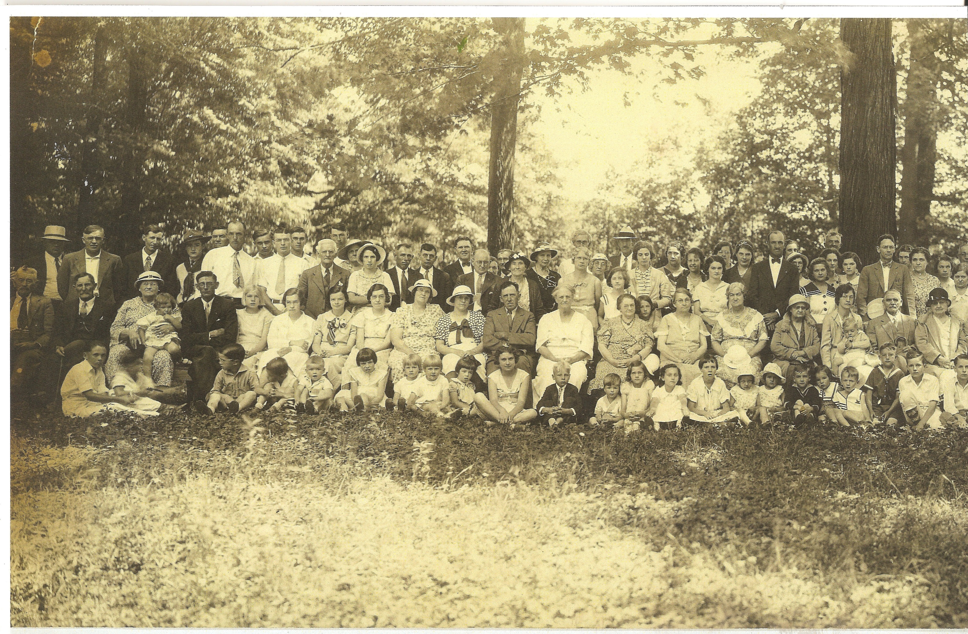
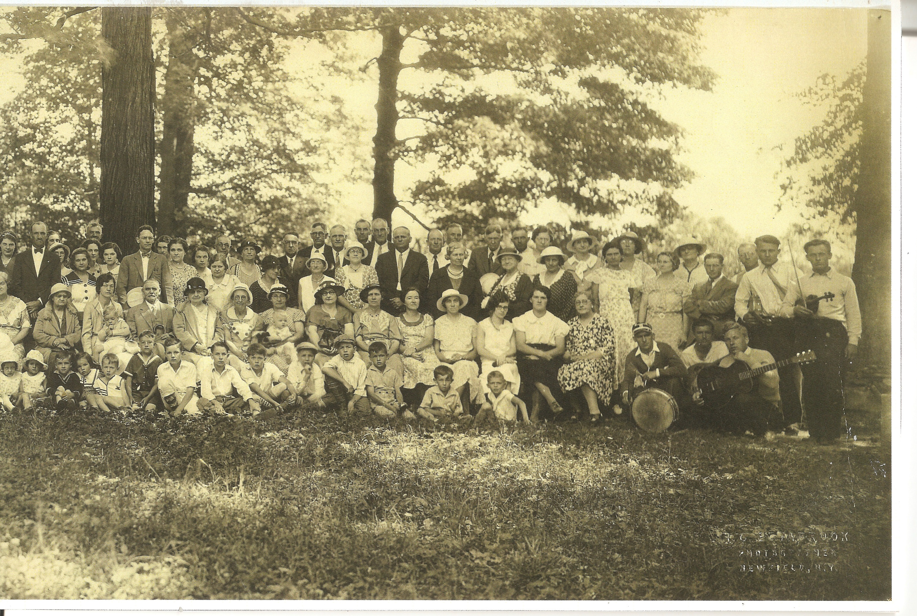
Pictures
Below are pictures (split) of Schaber’s Grove Community Picnic (Corner of Mecklenburg and Enfield Main Road) from the (estimated) the early 1930’s. Do you know anyone in the picture? Please contact the Town Historian at historian@townofenfieldny.gov with any leads.
Throw Back Thursday
Do you have a photo of a past event, building, or other feature of Enfield you would like to share? Email the photo to the Town Historian at historian@townofenfieldny.gov and we’ll feature it in an upcoming column.
We invite readers to share memories relating to our weekly columns by sending an email to the Town Historian at historian@townofenfieldny.gov.
| Name | About | Document |
|---|---|---|
| Enfield Bicentennial | About the beginning infrastructure of Enfield. | Bicentennial (PDF, 150 KB) |
| Clair Updike | Appreciation for Supervisor Clair's many years of service across a variety of Committees, from Conservation to Accounts to Social Services, on the Board of Supervisors. | Clair Updike (PDF, 315 KB) |
| Agape Church | The members of the Agape Church met in various buildings until 1982, when John and Helen Smith donated land to the organization. Included is a picture of the building. | Agape Church (PDF, 92 KB) |
| Applegate Road | History of the Cowbell Farm located at 230 South Applegate Road. Included are two pictures of the land. | Applegate Road (PDF, 124 KB) |
| Applegate School | About the Stone School House located east side of the Applegate Road. Includes a picture of several students, a teacher, and others in front of the building. | Applegate School (PDF, 209 KB) |
| Applegate Tavern | The Applegate Tavern was the first log tavern built in 1807. Included is a picture of the tavern dated 1955. | Applegate Tavern (PDF, 190 KB) |
| Baptist Parsonage | The Baptist Parsonage was located at 144 Enfield Main Road. Miss Elizabeth C. Bock and Llyod D. Rumsey were married here in 1919. Included is a picture of the building. | Baptist Parsonage (PDF, 191 KB) |
| Barn | Included is a 1920s picture of a barn on 487 Enfield Center Road before it was burnt down. The barn was originally part of a farm. | Barn (PDF, 186 KB) |
| Supervisors William Lucas Bostwick and Samuel V. Graham | About the lives and deaths of two Enfield Town Supervisors. Both served during the mid to late 1800s. Included is a picture of a note. | William Lucas Bostwick and Samuel V. Graham (PDF, 410 KB) |
| Budd School House | Article includes a short biography of Lottie May Eddy Vann, a school teacher, and one of her souvenirs. Also includes a picture of the Budd School House before it was sold and torn down. | Budd School House (PDF, 59 KB) |
| Catskill Turnpike | This location, 1795 Mecklenburg Road was previously used as a rest stop for livestock drovers. Included is a picture of the house built in this area in 1817. | Catskill Turnpike (PDF, 188 KB) |
| Christian Church | Included is a picture of the Christian Church established in 1821. The building was in front of the Christian cemetery. | Christian Church (PDF, 113 KB) |
| Enfield Centre Hotel | Included is a sketch of Enfield Centre Hotel drawn by Erza D. Chase dated March 20, 1879. The land has changed hands numerous times. | Enfield Centre Hotel (PDF, 274 KB) |
| Enfield Centre Hotel Postcard | Includes a picture of a scanned postcard labeled Hotel Enfield Center, 1875. Changes are noted between the appearance of the postcard and the sketch. | Enfield Centre Hotel Postcard (PDF, 326 KB) |
| Enfield Centre Post Office | Pictured is the Post Office and Blacksmith Shop. There is a short timeline of various postmasters. | Enfield Centre Post Office (PDF, 346 KB) |
| Enfield Centre School | Picture of the old Enfield Center School located across from the Methodist Church. | Enfield Centre School (PDF, 203 KB) |
| Display of Enfield Centre School District #6 | Picture of a display made by Jenny Wurster with the help of Warena Ramsey, Helen Jackson Hetherington, and Mr. Jack Hubbell. | Display of Enfield Centre School District #6 (PDF, 644 KB) |
| Enfield Court - Bob Bock | Picture of house at 101 Rockwell Road, where Justice of Peace Bob Cock held Enfield town court during the mid 1900s. Included is a short history written by the Dave Bock Family. | Enfield Court - Bob Bock (PDF, 194 KB) |
| Enfield Falls Community Building | There is a history of the building, including the lease contract and agreement. Included is a picture of the Community Building. | Enfield Falls Community Building (PDF, 146 KB) |
| Enfield Power Equipment | History of and picture of Enfield Power Equipment, a company which sold a variety of tools, clothing, and toys. They also offered chemical furniture stripping as a service. | Enfield Power Equipment (PDF, 106 KB) |
| Enfield Fire Hall | History of and picture of the Fire Hall, built by the Volunteer Fire Company in 1948-9. It is now used as the Community Building / Court / Code Enforcement Office. | Enfield Fire Hall (PDF, 66 KB) |
| Annual Health Report from 1935 | During this time, there was great concern regarding disease and the Flood of 1935. Included is an annual health report from Dr. Beardsley, the Health Officer representing Enfield. | 1935 Health Report (PDF, 367 KB) |
| Harvey Hill | Sketch of the "old" Curry Farm on 235 Harvey Hill Road, drawn by Ezra D. Chase. Includes short biography of Ezra. | Harvey Hill (PDF, 195 KB) |
| Ithaca Farm Equipment | History and image of Ithaca Farm Equipment, a company operated by Mervin Schroeder that sold equipment and completed repairs. Also includes information about its mechanics and timeline of the building. | Ithaca Farm Equipment (PDF, 191 KB) |
| Methodist Episcopal Church | The Church was located at Kennedy's Corners at 1538 Mecklenburg Road. The building was destroyed and rebuilt before the church was closed in 1984. | Methodist Episcopal Church (PDF, 444 KB) |
| Mervyn Schroeder Barns and Wagon House | Includes two separate pictures of the barns and wagon house on Mecklenburg Road near VanDorn Road. | Mervyn Schroeder Barns and Wagon House (PDF, 136 KB) |
| 2504 Mecklenburg Road | Includes a picture of 2504 Mecklenburg with a number of people standing by the fence. | 2504 Mecklenburg Road (PDF, 223 KB) |
| Methodist Parsonage | Includes a picture of the house at 205 Enfield Main Road, where some church activities were held. Also includes a short history of the "Silver Tea" of 1941. | Methodist Parsonage (PDF, 114 KB) |
| Millers District #4 School | Includes two pictures of the School, later closed in 1956 with the consolidation of schools into the Ithaca City School District. | Millers District #4 School (PDF, 237 KB) |
| Mouse Nest House | Includes a picture of a map of where the Mouse Nest House was located. Includes a short investigation into its history. | Mouse Nest House (PDF, 279 KB) |
| Nobles School House District #10 | The Little Red School House (Nobles) District #10 was located between Griffin and Rumsey Hill Roads. The school was closed in 1956 with the consolidation of schools into the Ithaca City School District. | Nobles School House (PDF, 353 KB) |
| Quilts | The traditon of the annual Harvest Festival and the quilts began in 1975. Included is a picture of a quilt from the 1980s. | Quilts (PDF, 696 KB) |
| Red and White | The "Red and White" grocery store was operated by Anna and William Jones and located in Enfield Center. Included is a picture of the storefront. | Red and White (PDF, 201 KB) |
| Rolfe School District #2 | Included is a picture of the school house, which was closed in 1956 with the consolidation of schools into the Ithaca City School District. There is also a writing by Eunice Beardsley about her memories of the school. | Rolfe School District #2 (PDF, 198 KB) |
| Rumsey Cemetery | Detailed article about the Rumsey Cemetery, and in particular the double headstones typically saved for twins and husband/wife parirs. | Rumsey Cemetery (PDF, 379 KB) |
| Rumsey Loomis Machien Company | The Rumsey Loomis Machine Company was located at 1514 Mecklenburg Road and owned by Stan Rumsey. The business was advertised for work in milling, turning, plastics, steel, and aluminum. | Rumsey Loomis (PDF, 136 KB) |
| Harvey Hill School District #11 | There is a writing by Blanch San Soucie Stout of their memories at Harvey Hill. Included is a picture from Catherine Chase of over 15 students and 4 teachers. The school was closed in 1956 with the consolidation of schools into the Ithaca City School District. | Harvey Hill (PDF, 337 KB) |
| The Stone House | The history of a house built by Keturah (Dunlap) and Charles Woodward, originally from England. Includes a picture of the house. | Stone House (PDF, 197 KB) |
| Old Town Barn | The Old Town Barn was used to house town highway equipment. Included is a picture of the building before it was demolished in 2008. | Old Town Barn (PDF, 266 KB) |
| Woodside Inn | The Woodside Inn, built in 1938, was originally part of the Rodrick Byrum farm. The property has changed hands numerous times, and also hosted a number of Community events such as chicken barbecues. Included is a picture from 1945. | Woodside Inn (PDF, 1522 KB) |